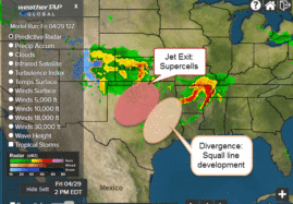
Storms are rumbling already through northern parts of Texas, Oklahoma, Kansas, & Arkansas – but as the day progresses and daytime heating kicks in – a significant round of severe weather is expected for this afternoon and tonight for Texas and Oklahoma – eventually moving eastward.
The EarthCast Global Model forecast of the winds at 3000ft from the 00Z model run shows the complex dynamics at the jet stream level very well.
There are two main areas of concern:
Southwest Oklahoma stretching into Central Oklahoma where the jet exit region is likely to spark the development of rotating supercells.
Central and North Texas where an area of upper level divergence will lead to the development of a squall line that will move eastward into East Texas and eventually Louisiana and Arkansas.
We’re keeping a close eye on the situation and you can too with weatherTAP.com.
Pamela McCown
EarthCast Technologies, LP


